当前位置:
X-MOL 学术
›
Agric. For. Meteorol.
›
论文详情
Our official English website, www.x-mol.net, welcomes your
feedback! (Note: you will need to create a separate account there.)
CrowNet: a trail-camera canopy monitoring system
Agricultural and Forest Meteorology ( IF 5.6 ) Pub Date : 2025-06-01 , DOI: 10.1016/j.agrformet.2025.110596
Francesco Chianucci, Alice Lenzi, Emma Minari, Matteo Guasti, Silvia Gisondi, Marco Gonnelli, Simone Innocenti, Carlotta Ferrara, Alessandro Campanaro, Paola Ciampelli, Andrea Cutini, Nicola Puletti
|
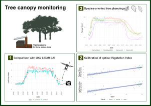
Continuous monitoring of forest canopy structure and phenology is pivotal for the assessment of ecosystem responses to environmental variability and changes. The present study evaluated the use of repeat digital trail cameras as a low-cost, flexible, and accessible in situ monitoring solution for quantifying daily canopy attributes, including effective leaf area index (Le) and canopy cover. A trial camera monitoring network (CrowNet) was established encompassing 20 forest stands in Italy, under different management and environmental conditions, resulting in over 44,000 daily images collected over three years. We demonstrated that taking the mean daily canopy attribute allowed to obtain smooth time series from trail cameras, from which phenological transition dates can be inferred. Daily canopy attributes were validated against manual digital cover photography measurement. To further explore the applicability of this monitoring solution, we performed a comparison between daily Le time series derived from a subset of trail cameras located in beech forests and data collected by multitemporal UAV LiDAR. Results demonstrated the close agreement between the two methods across the entire phenological period (start and end of season). We also illustrated use of continuous trail camera estimates to calibrate a vegetation index (NDVI) to infer leaf area and canopy cover from optical multi-temporal UAV data. We further investigated use of trail camera to detect species-specific differences in tree phenology from time series acquired in a mixed oak-hornbeam forest. We found different canopy structure and phenological transition dates in three broadleaved species (oak, ash, hornbeam), supporting the effectiveness of trail cameras for species-oriented phenology monitoring. We conclude that trail cameras provide a reliable solution for daily canopy monitoring, offering a significant cost-effective and flexible alternative to traditional field methods and providing potential to calibrate, validate or integrate remotely-sensed information. However, camera failures during adverse weather, and the need for more efficient image data quality checking procedures, still represent open challenges. Future improvements, such as weatherproof housing and automated pre-processing screening procedures, are therefore recommended for making trail camera fully operational in ground canopy and phenology monitoring.
中文翻译:

CrowNet:一种跟踪相机树冠监测系统
持续监测森林冠层结构和物候对于评估生态系统对环境变异和变化的反应至关重要。本研究评估了使用重复数字跟踪相机作为一种低成本、灵活且易于使用的原位监测解决方案,用于量化每日冠层属性,包括有效叶面积指数 (Le) 和冠层覆盖率。建立了一个试验性相机监控网络 (CrowNet),包括意大利的 20 个林分,在不同管理和环境条件下,三年内每天收集超过 44,000 张图像。我们证明,采用平均每日冠层属性可以从跟踪相机获得平滑的时间序列,从中可以推断出物候过渡日期。根据手动数字封面摄影测量验证每日冠层属性。为了进一步探索这种监控解决方案的适用性,我们对来自山毛榉林中跟踪相机子集的每日 Le 时间序列与多时相无人机 LiDAR 收集的数据进行了比较。结果表明,两种方法在整个物候期(季节开始和结束)之间具有密切的一致性。我们还说明了使用连续跟踪相机估计来校准植被指数 (NDVI),以从光学多时相无人机数据中推断叶面积和树冠覆盖。我们进一步研究了使用跟踪相机从橡树-鹅耳枥混交林中获得的时间序列中检测树木物候的物种特异性差异。我们在三种阔叶树种(橡树、白蜡树、鹅耳枥)中发现了不同的冠层结构和物候过渡日期,支持了跟踪相机对面向物种的物候监测的有效性。 我们得出的结论是,跟踪相机为日常树冠监测提供了一种可靠的解决方案,为传统的现场方法提供了一种重要的经济高效且灵活的替代方案,并为校准、验证或集成遥感信息提供了潜力。然而,恶劣天气下的相机故障以及对更高效的图像数据质量检查程序的需求仍然是公开的挑战。因此,建议未来的改进,例如防风雨外壳和自动预处理筛选程序,以使跟踪相机在地面冠层和物候监测中全面运行。
更新日期:2025-06-01
中文翻译:
CrowNet:一种跟踪相机树冠监测系统
持续监测森林冠层结构和物候对于评估生态系统对环境变异和变化的反应至关重要。本研究评估了使用重复数字跟踪相机作为一种低成本、灵活且易于使用的原位监测解决方案,用于量化每日冠层属性,包括有效叶面积指数 (Le) 和冠层覆盖率。建立了一个试验性相机监控网络 (CrowNet),包括意大利的 20 个林分,在不同管理和环境条件下,三年内每天收集超过 44,000 张图像。我们证明,采用平均每日冠层属性可以从跟踪相机获得平滑的时间序列,从中可以推断出物候过渡日期。根据手动数字封面摄影测量验证每日冠层属性。为了进一步探索这种监控解决方案的适用性,我们对来自山毛榉林中跟踪相机子集的每日 Le 时间序列与多时相无人机 LiDAR 收集的数据进行了比较。结果表明,两种方法在整个物候期(季节开始和结束)之间具有密切的一致性。我们还说明了使用连续跟踪相机估计来校准植被指数 (NDVI),以从光学多时相无人机数据中推断叶面积和树冠覆盖。我们进一步研究了使用跟踪相机从橡树-鹅耳枥混交林中获得的时间序列中检测树木物候的物种特异性差异。我们在三种阔叶树种(橡树、白蜡树、鹅耳枥)中发现了不同的冠层结构和物候过渡日期,支持了跟踪相机对面向物种的物候监测的有效性。 我们得出的结论是,跟踪相机为日常树冠监测提供了一种可靠的解决方案,为传统的现场方法提供了一种重要的经济高效且灵活的替代方案,并为校准、验证或集成遥感信息提供了潜力。然而,恶劣天气下的相机故障以及对更高效的图像数据质量检查程序的需求仍然是公开的挑战。因此,建议未来的改进,例如防风雨外壳和自动预处理筛选程序,以使跟踪相机在地面冠层和物候监测中全面运行。


 京公网安备 11010802027423号